 Kamanthi Wickramasinghe
Reply To:
Name - Reply Comment
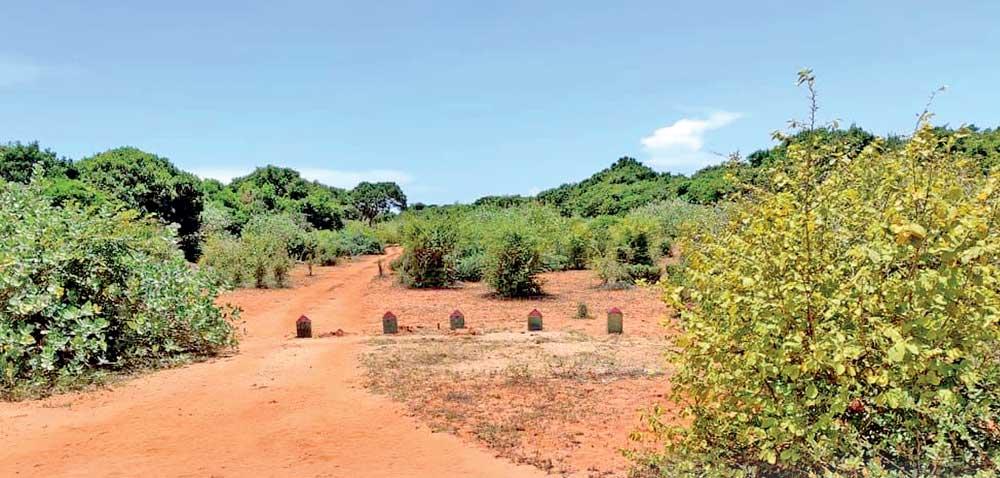
Proposed road via Wilpattu National Park (pic by Nayanajeewa Bandara)
 “Vehicles going to and fro would kill animals. Larger animals such as bears were knocked down by speeding vehicles and killed in the past. The third issue is that when there is an edge to a protected area to a certain degree inwards from the edge there is what is called the ‘edge effect’ where invasive alien species of animals and plants get rooted”
- Dr. Jagath Gunawardena, Senior Environmental Lawyer
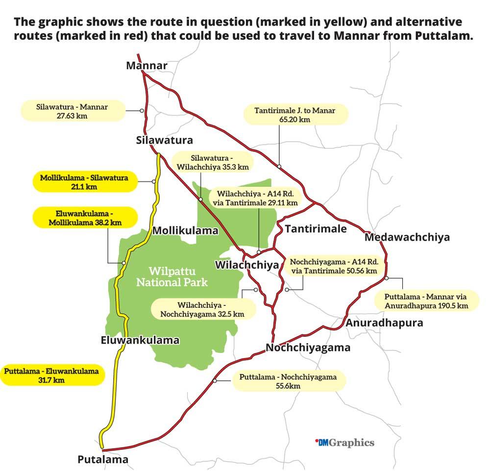
The much disputed Mannar-Puttalam road via Wilpattu National Park yet again made headlines when President Anura Kumara Dissanayake recently said that the government is considering ways and means of reopening this road. The road, which was initially built by the Army during the war, was utilised for logistical purposes. Right now, this road, which is in a dilapidated state, has been closed due to a court order following complaints filed by the Environmental Foundation Limited, Wildlife and Nature Protection Society and several other environmental conservation groups. However, environmentalists argue that the reopening of this road would cause an irreversible harm to the flora and fauna of the Wilpattu National Park (WNP), which is also home to a high density of leopards and claims beings made that it is quite an unwise move.
History of the Mannar-Puttalam road
From 1998-2009 the WNP was closed to the public due to the civil war. This route was constructed by security force to facilitate the capture of the rice bowl area of Mannar district, between 2007 and 2008. Thereafter the road hadn’t been in use. The A32 route from Mannar-Pooneryn was also closed due to security reasons. However, after the war concluded the then Defence Secretary Gotabaya Rajapaksa, Basil Rajapaksa and Rishard Bathiudeen decided to open the WNP to the public. Between 2010 and 2013 Bathiudeen was also instrumental in illegally clearing the buffer zone belonging to the Park to construct settlements for political gains.
The Park came under the purview of the Army during the war. During this time the Sri Lanka Navy cleared two roads for logistical purposes. One route was towards the Western end of the Park adjacent to the sea while the other route (a 35km stretch) bisected through the northern part of the Park. The route which bisected the National Park was reopened in January 2010, just before the Presidential Elections, despite protests from environmental groups. Environmentalists claim that the main objective of reopening this route was to encroach the lands adjacent to the sea. Even though this route was named the ‘old Mannar-Puttalam road’ according to maps issued by the Surveyor’s Department in 1984 and aerial photographs taken prior to 2009, such a road doesn’t exist. These roads didn’t exist when the park was gazetted between 1938 and 1973.
Significance of Wilpattu National Park
The WNP spans across 131,693 hectares and is home to an abundance of flora and fauna. The Park includes the Wilpattu northern sanctuary, Thabbowa sanctuary and Weerakulicholai-Eluwankulam forest reserve. The Park is located bordering Malwatu Oya and Modaragam Aru from the North, Kala Oya from the South, the coastal stretch from the West and border villages including Hunuwilagama, Vilachchiya and Thanthirimale. The Park is home to over 248 species of fauna out of which around 21 species are endemic to Sri Lanka. Conservationists claim that there are around 30 species of fauna which are threatened. WNP comprises many villus (small lakes) making it a unique habitat. According to environmentalists one could spot the elephant, leopard, bear, blue whale and sperm whale at Wilpattu National Park and its surrounding coastal zone.
In addition to its natural heritage, the WNP boasts of a rich archeological heritage. Evidence of ancient civilizations that existed during the country’s golden era are buried within the thick jungles of the WNP. As such as many as 68 archeological sites scattered throughout the Park showcase chronological proof of prehistoric life. According to the DWC, these sites have been categorised as Miocene Fossil Sites, Prehistoric Sites which include Paleolithic and Mesolithic sites, Proto-historic and Historical-Megalithic and Monastic Ruins and Irrigation and Agricultural sites.
Four main archaeological sites at the WNP include Kuda Vilachchiya Tank, Pomparippu Urn Burial Site, Ochchappu Kallu ancient Buddhist shrine and Kuderimalai Point.
Legality of the route
In 2010, EFL filed a case (SC/FR/224/10) against opening this route for commercial purposes and the case is in progress. Since 2009 Wilpattu has been subject to rapid deforestation attempts and illegal encroachment. In response, the Supreme Court granted an interim order in 2010, halting further development activities within Wilpattu. According to the Fauna and Flora Protection Ordinance (FFPO) Amendment of 2009 no construction project can be carried out without officially obtaining prior written approval, whether by a private party or the state. Sections 3 and 6 underpin the illegality underlying the construction of a road through a National Park and also stipulates that it is illegal for anyone to use such a construction due to restricted access. In addition to the legal framework provided by the FFPO, the Forest Ordinance, the National Environmental (Protection) Act, the Soil Conservation Act, the Felling of Trees (Control) Act, the Land Development Ordinance, the Crown Land Ordinance and the Land Settlement Ordinance have also vested substantive legal responsibilities on administrative bodies.
Predicted consequences
“This road is not suitable for people because a road running through a protected area is a barrier to the movement of animals in its simplest terms,” said senior Environmental Lawyer Dr. Jagath Gunawardena. “Vehicles going to and fro would kill animals. Larger animals such as bears were knocked down by speeding vehicles and killed in the past. The third issue is that when there is an edge to a protected area to a certain degree inwards from the edge there is what is called the ‘edge effect’ where invasive alien species of animals and plants get rooted and established in these areas. Thereafter the diversity of the disturbed area gets eroded over time. Then the protected area gets reduced. This the worst thing that could happen to a national park,” he explained.
He also warned that having a public road through a protected area may help in facilitating bio-theft, illegal poaching and illegal plant collection. “When there’s a public road in a protected area we can’t post guards in every segment of the road. So there is always room for people to engage in nefarious activities. The fundamental legal point is that a national park is a legal area protected under Article 2 sub article 1 of the FFPO and according to the law a person can enter a national park only under provisions of Section 5. Section 5 categorically states that a person could enter a national park only for scientific studies, observing of wildlife or for recreation purposes. So they can’t have a road via a national park because it a travesty of existing legal provisions,” he added.
However, government factions are in an attempt to justify the construction of this route by claiming about a route that falls via Yala National Park. But Dr. Gunawardena opines that the Buttala-Kataragama road is situated adjacent to the Yala National Park and that it doesn’t justify the construction of a new road. “It was an existing road at the time the area was being declared and it doesn’t bisect the Yala National Park,” he said.
Failed attempts
In July 2024, when the Eluvankulam causeway collapsed, plans were underway to introduce two buses along the B379 route. According to authorities, one bus from Mannar and the other from Puttalam would bring passengers to the Eluvankulam transit point and would interchange buses. However, this plan came under scrutiny by environmental groups as the route was too sensitive for the passage of buses as there were no speed limits.
According to the Road Development Authority’s 2019 National Road Network map, route B379 was classified as a B class road. The definition of a Class B road is that it channels traffic from residential areas, town centers and industrial zones into Class A roads and facilitates the connection between administrative districts and provincial cities.
However, authorities including the Sri Lanka Transport Board and Department of Wildlife Conservation were in a dilemma as there were issuing in approving this proposal. The Daily Mirror later learned that it was a proposal by former MP Ali Sabry Raheem. When this newspaper contacted Raheem he told that the introduction of two buses was a temporary measure to make commuting easier for devotees who were attending the Madhu Church festival. But environmentalists argued that the road had to be developed prior to introducing a bus. But during a previous instance, when a bus actually operated via this route, there had been several roadkills as the speed limit was around 60-80 kmph.
(Additional reporting by Nayanajeewa Bandara
– Moneragala)
When this writer had a rare opportunity to travel via this route while on a nature trail four years ago, she was able to catch a glimpse of a family of Malabar Hornbills flying from one tree to another, lost in their own world. We spotted a leopard’s footprint, indicating that it had been on a prowl, eyeing for possible prey in addition to elephant dung, both fresh and old that punctuated the dilapidated path, left for the wilds to take over in the best interest of the environment.
On May 7 (Wednesday) the state’s undertakings were formally recorded before the Supreme Court and the Fundamental Rights Case (SC/FR/224/2010) filed by EFL and supported by Uditha Egalahewa PC and co-petitioners was terminated, bringing a nearly 15-year legal battle to a successful close as described by the litigants.
Deputy Solicitor General Dr. Avanti Perera recorded the following statements in the Supreme Court:
Public ‘through traffic’ across the park will not be permitted
Entry into the Park is restricted to members of the armed forces and police performing lawful duties. All other entries must comply with provisions of the FFPO
There is no objection to the road being maintained as a gravel road with any necessary repairs carried out in that form
The ruling underscores that environmental laws must be upheld in all national planning and decision-making processes.
 When contacted to inquire about the government’s plan regarding this matter, Deputy Minister of Environment Anton Jayakody said that the matter is still at a discussion stage and affirmed that a decision would be taken after consulting all stakeholders. “There had been buses that travelled via this route some 30-40 years ago,” he told the Daily Mirror. “Thereafter it was used by the Navy. However the road is now in a dilapidated condition and is not in use. Right now we are still having discussions with stakeholders including the Central Environmental Authority, Road Development Authority, Environment Ministry, Wildlife Department and Forest Department. We will setup a committee to analyse how this could be done. But we will not reopen the road until this Committee submits its recommendations. The Committee comprise stakeholders from the aforementioned departments. If this road is reopened we will ensure that there’s minimum damage caused to the environment,” he underscored.
Responding to a query on risk of urbanization in the event a road is being developed via the National Park, Jayakody said that the government would not leave room for urbanization. “This route falls within the buffer zone of the Wilpattu National Park so therefore it cannot be urbanised. There are similar routes via Yala National Park for instance that people use to reach Buttala. So it all depends on how the route is being gazetted,” he explained further.