 Kamanthi Wickramasinghe
 Reply To:
Name - Reply Comment
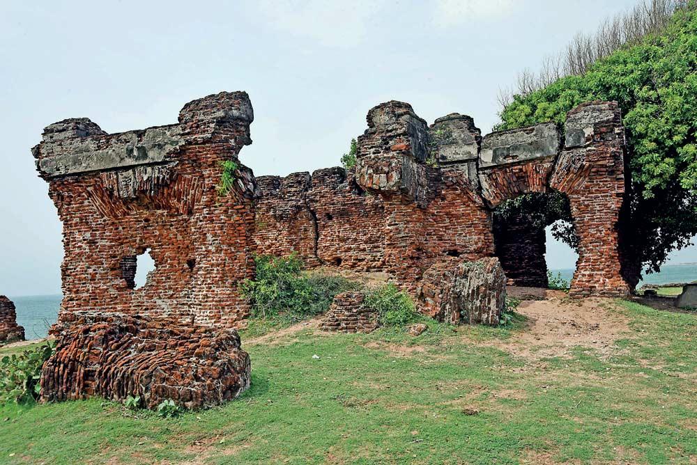
One of the most iconic landmarks in Mannar District is the Doric Bungalow, located in Arippu East
(Pix by Kushan Pathiraja)
 Today, around two signboards on the way to Arippu remind visitors of the thriving pearl fishery industry back in the day
The Zonal Archaeology Office has requested from the Coast Conservation Department to construct a breakwater to minimise impact of coastal erosion near archaeological sites
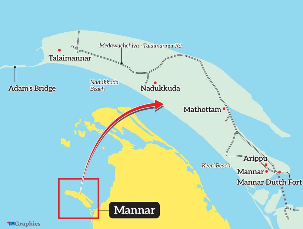
One of the most historically and archaeologically important towns in Sri Lanka at present is Mannar. This is because its history dates back to over 1500 years, especially with its role as one of the most prosperous maritime trading hubs of yesteryear. Historical accounts indicate that Manthota (now known as Mannar) was a large port believed to have harbored up to 1000 vessels and navigation routes for mariners around shoals and islands in the vicinity. But today, Mannar has become vulnerable to destruction as a result of unplanned development.
Buried history
Mannar was known for Pearl fisheries. Renowned environmental architect and historian Sunela Jayewardene in her maiden book titled ‘The Line of Lanka’ describes Lanka’s pearl banks as follows;
“Along the Mannar coast, just south of Neduntivu, encrusting the shallow sandy seabed, once lay the pearl banks of Lanka. Harvested for centuries, they provided the world with the finest pearls. During the short ‘season’, a temporary town of Pearl fishers sprung up, attracting fortune hunters from across the ancient world, but particularly large numbers of Africans and Arabs. They came primarily as pearl divers, who arrived with their curious, bone nose clips, shaven heads and slept on board the dhows they sailed in…”
But once the British captured the island, Jayewardene notes that the pearl banks were finally closed and the bounty which had been sustainably harvested since time immemorial, was exhausted in just over a century. Today, around two signboards on the way to Arippu remind visitors of the thriving pearl fishery industry back in the day.
Remnants of Doric Bungalow
One of the most iconic landmarks in Mannar District is the Doric Bungalow, located in Arippu East. This is the residence of Frederick North, the first Governor of Ceylon; this dwelling was built between 1802 and 1804 to oversee pearl fisheries. What makes it truly unique is its Doric architecture with sturdy and simple columns constructed with brick and mortar and walls coated with lime and burnt oyster shells resembling marble.
An in-detailed account of the bungalow written by James Cordiner in ‘A Description of Ceylon’ published in 1807 reads as follows;
“There are four small bedrooms on the ground floor, one at each corner; a spacious flight of stairs occupies the center; and two well proportioned rooms above extend from east to west of the building, ornamented on each side by graceful colonnades. One of these is used as a dining room, and calculated to contain a party of twenty persons. The other is his excellency’s bedchamber. At one end of it a winding staircase is cut off, leading up to the terraced roof, from which there is a most extensive prospect of the level country in three directions, and in the forth of the open sea, and a fine view of the line of boats, when they are returning from the banks of oysters. The house is pleasantly situated on an elevated bank, about a stone’s cast from the sea; apartments are delightfully cool being completely surrounded by Venetian doors, or windows reaching to the floor, and constantly fanned by a regular succession of land and sea breezes. Near it several sets of temporary rooms are constructed of wooden pillars and Palmyra leaves, affording accommodation for persons for whom the Doric building cannot contain.”
From what was earlier a two-storey building, the ground floor of the main building still stands strong. But for how long remains a question. When this writer visited the Doric Bungalow in 2022, she was able to reach the upper floor of the Bungalow and catch a glimpse of what looked like a room, to get the feel of what it would have been like back in the day. But today, the weathered staircase would take you to the upper floor, but the room that this writer previously saw is no more. Huge chunks of the building now lie near the seashore. As a result of coastal erosion the remaining structure is in a vulnerable condition and nobody knows for how long it would remain intact. The foundations of temporary rooms described by Cordiner are still visible to visitors.
What is quite unfortunate is that no attempt has been made to conserve or preserve this archaeological gem steeped in history. When inquired, an official from the Zonal Archaeology Office told the representative of this newspaper that a request has been made to the Coast Conservation Department to construct a breakwater to minimise the impact of coastal erosion.
Revival of the Mannar
Dutch Fort
Jayewardene in her second book titled ‘Ravana’s Lanka’ refers to the bustling port of Mahatittha which is an early reference to Mannar. According to her, Mannar was known variously through time as Mahatittha, Manthai, Manthota and Mannarama. The Kadamba Nadi – during times when Mannar was known as Mahatittha, Manthai etc., the Malwathu Oya was known as Kadamba Nadi, was a river wide-enough for medium-sized watercraft which wound its way from Anuradhapura to Mahatittha. Another one of its iconic archaeological remains is the Mannar Dutch Fort. But according to Jayewardene, a far more impressive structure once stood on the mainland. She believes that the Mahatittha Fort situated north of the modern causeway that links to the island of Mannar, held a settlement of substantial scale; an operational base that had been designed to oversee a long-time venture.
But the Dutch Fort, built in 1560 by the Portuguese and lager fortified by the Dutch, tells a story of colonial conquest and local resilience. The dilapidated entrance is now under construction; this is a project by the Sri Lanka Tourist Board and Department of Archaeology. The coral and limestone structures that once held this massive fort complex intact is now being replaced with cement, as part of restoration initiatives. Indeed its antique look is now being disturbed, but according to Archaeology Department officials, they have limited options as far as building materials are concerned to restore the structure. In their opinion, corals used to build the structure back in the day cannot be found and it would be time-consuming.
Within the fort, crumbling structures whisper tales of a bygone era, quarters for soldiers, storerooms, and even a chapel. When one walks around the fort, it gives you a glimpse of its location and how it served as a military establishment to keep the enemy away. What is lacking is the story behind this fort complex, a kind of a narrative for visitors to follow and immerse themselves in the untold history of Mannar. An information Centre is one of the additions under the recent restoration initiatives.
Financial constraints are a main challenge for the Archeology Department and as a result they are unable to carry out restoration initiatives as expected. The Daily Mirror learned that apart from over 30 archaeology sites already discovered in Mannar, over 60 more sites have recently been found. Certain others which remain within Forest Conservation Department and Wildlife Department lands are yet to be discovered.
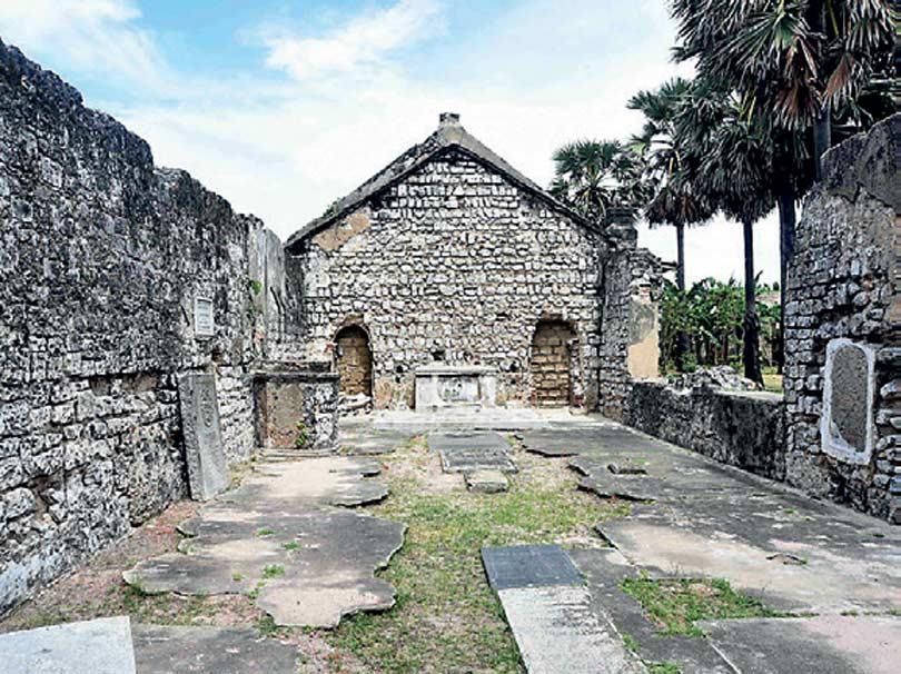 The chapel
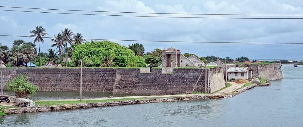
Mannar Dutch Fort as seen from the causeway