Reply To:
Name - Reply Comment


Last Updated : 2024-05-10 15:33:00
11 August 2020 12:06 am - 0 - {{hitsCtrl.values.hits}}

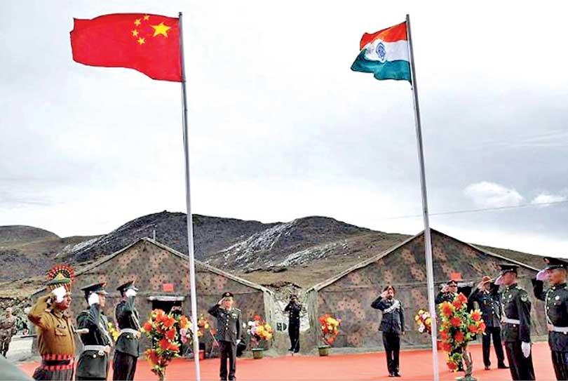
Talks on boudary between the Indian and Chinese militaries
 Maps have been linked to war and conflict from the earliest times. According to S.J.Schuler (360.here.com), the oldest is a Chinese “Garrison map” dated 180 BC which was discovered in a cave in Hunan in 1973. The Arabs and the Ottoman Turks used maps in their military campaigns in Europe. In 1539, as England faced the threat of invasion from France, Henry VIII’s minister Thomas Cromwell ordered (in English of his time): “Expert men of every shire in Ingland beyng nere the see” to draw up maps “of all the places… wher any daunger of invasions ys like to be and to certifie the sayd daungers and also best advises for the fortificacion thereof.”
Political maps were not drawn until after the Treaty of Westphalia in 1648 because it was only after this European treaty that the concept of territorial sovereignty took root in
international relations.
 In medieval times and also during the early stages of European rule in India and Ceylon, native kings, and later the Portuguese, Dutch and British rulers, based their dominance on political alliances in which less powerful entities swore allegiance to the bigger power and accepted the latter’s suzerainty. Actual and direct territorial control was not exercised or considered necessary. Furthermore, at that time, boundaries between principalities were indeterminate and changing with every shift in the balance of power. In such a state of flux, territoriality was not a key factor and therefore, political map making made little sense.
However, things changed when concepts of “territorial sovereignty” and the “nation state” were accepted as the norm in international relations. The era of political maps defining sovereign territories dawned. Claims and counter claims about territories often ended up in armed or economic conflicts as territorial sovereignty had become sacrosanct.
Cartographic Wars In South Asia
South Asia has been a theatre of cartographic wars. The Sino-Indian conflict from the 1950s to this day has been over boundaries still not demarcated due to conflicting claims. In 1953, 1961 and 2019, India published maps through which it asserted its claims vis-à-vis China and Pakistan. China, Pakistan and Nepal also made their claims through maps. Conflicting cartographic claims led to the Sino-Indian war in 1962 and a brief clash in June 2020 followed by an Indian economic boycott of China.
In early November 2019, India issued a new official map following some constitutional and territorial changes in the State of Jammu and Kashmir (J and K) bordering Pakistan and China. On October 31, the Indian government divided J and K into two parts, J and K and Ladakh, and made them “Union Territories” to put them directly under Delhi’s control.
As Pakistan and China protested saying that the act was “illegal” India issued a new map in the first week of November to assert its claims. That map showed, as India’s territory, areas which China and Pakistan claimed or actually controlled. Pakistan claimed J and K and actually controlled a part of Kashmir called “Azad” Kashmir, Gilgit and Baltistan and China claimed Ladakh and actually controlled Aksai Chin. The new political map of India showed three districts of Pakistan-held Kashmir namely, Muzaffarabad, Mirpur and Punch, as part of Jammu and Kashmir, and Gilgit-Baltistan, as part of Ladakh.
India’s response to Pakistan and China’s claims was that the whole of the former Princely State of J and K was handed over it in 1947 through a legally valid Instrument of Accession by then ruler of J and K, Maharajah Hari Singh. India has for long been accusing Pakistan of forcibly occupying parts J and K in 1948 and China of grabbing Aksai Chin in the 1950s.
Not to be outdone, on August 4, Pakistani Prime Minister Imran Khan issued a new political map showing J and K, Ladakh, and also Junagadh in Gujarat and Sir Creek within Pakistan. As reason for his territorial claim, Imran Khan said Pakistan rejects the steps taken by India on August 5, 2019 “to quell the Kashmir peoples’ right to self-determination”.
Indo-Nepal Map War
India and Nepal are also embroiled in a cartographic war. In November 2019, the newly published India map showed Kalapani, Limpiyadura and Lipulekh as being a part of its Uttarakhand State. But Nepal claimed them. In response to Nepal’s protest, it was agreed to discuss the issue at the Foreign Secretaries’ level. But no such meeting took place, partly due to India’s preoccupation with COVID-19. But coming under increasing domestic pressure, on May 20, 2020, the Nepalese government issued a map showing all three places as being part of Nepal. The step was overwhelmingly endorsed by the Nepalese parliament.
The government’s move to publish a new political map was prompted by India’s May 8 announcement that it had opened a road link via the Lipulekh pass to Kailash Mansarovar in Tibet with China’s nod. Having been left out of the deal, Nepalese Prime Minister KP Sharma Oli came under domestic political pressure to act. On August 2, 2020, the Nepalese government said it would send its new political map to Google and the international community by mid-August.
Complex Issue
According to the Nepalese, the 1816 Treaty of Sugauli between the Kingdom of Nepal and the British East India Company (which was then ruling India) had stated that the area East of the Kali or Mahakali river is Nepal’s and the area West of the river is India’s. As such, Limpiyadhura, Kalapani and Lipulekh are in Nepal. But officials in India claim that revenue records dating back to the 1830s show that the Kalapani area was administered as a part of the Pithoragarh district which is Uttarakhand State in India.
Alok Kumar Gupta writing for the Institute of Peace and Conflict Studies New Delhi, says that the Indian government conducted the first regular survey of the upper reaches of the river Kali in the 1870s and the official Indian map drawn in 1879 showed Kalapani as part of India. India holds that the 1879 map should be the reference point rather than the earlier maps as the earlier maps were inaccurate. But the Nepalese charge that the British rulers used the shifting course of the Mahakali river to advance Indian territory eastwards for strategic reasons, encroaching on Nepalese territory.
However, successive Nepalese governments had not challenged the 1879 map until 1990, pointed former Indian Foreign Secretary Shyam Saran in the Indian Express. In the early 1950s, after China occupied Tibet, India, with the consent of Nepal, set up 17 or 18 military-cum-police posts along the Nepal-China border. In 1969, Kirti Nidhi Bisht, the Nepalese Prime Minister, asked Indian Prime Minister Indira Gandhi to withdraw these posts. This was done except in Kalapani because it was not mentioned in the Nepalese list, Saran pointed out.
Further, when China and Nepal drew their boundary in 1961, it was stated that the Western extremity of the China-Nepal border started at the Tinker Pass, well east of Lipulekh Pass. “This cannot be refuted as this is in the formal documents,” Saran stressed. He further said that in 1954, when India and China concluded a trade and transit pact, six border passes were listed for the purpose. Lipulekh was included among them.
“There was no protest from the Nepali side. The first time that Nepal protested formally was in 2015 when India and China signed a MoU for conducting border trade between the two countries through Lipulekh Pass,” Saran noted. The cartographic conflicts between India on the one hand, and Pakistan, China and Nepal on the other, are unlikely to be settled any time soon, as territorial sovereignty is considered sacrosanct by all three.

Add comment
Comments will be edited (grammar, spelling and slang) and authorized at the discretion of Daily Mirror online. The website also has the right not to publish selected comments.
Reply To:
Name - Reply Comment

US authorities are currently reviewing the manifest of every cargo aboard MV

On March 26, a couple arriving from Thailand was arrested with 88 live animal

According to villagers from Naula-Moragolla out of 105 families 80 can afford

Is the situation in Sri Lanka so grim that locals harbour hope that they coul


7 hours ago
7 hours ago


09 May 2024

09 May 2024

09 May 2024