Reply To:
Name - Reply Comment
By Chaturanga Pradeep Samarawickrama
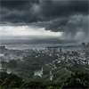
The expected shift in weather conditions due to the Intertropical Convergence Zone (ITCZ) has sparked public concern over national preparedness, as the island braces for increased rainfall from today (6).
According to the Meteorology Department, the convergence of winds from the Northern and Southern Hemispheres will intensify atmospheric instability, triggering widespread showers and thundershowers across the country.
Most parts of the island are expected to experience showers or thundershowers, with fairly heavy rainfall exceeding 75 mm likely in several provinces including the Western, Sabaragamuwa, Southern, Uva, Northern and Eastern regions, as well as Polonnaruwa District.
From this afternoon, weather conditions are expected to further deteriorate, with thundershowers forecast in most areas after 1.00 p.m. Cloudy conditions will persist over several provinces, while morning showers are also expected in affected regions.
Meteorologists have also warned of heavy rainfall exceeding 100 mm in parts of the Sabaragamuwa, Central and Uva provinces, along with several key districts including Ampara, Batticaloa, Galle, Matara and Polonnaruwa.
The forecast has renewed calls for authorities to strengthen early warning systems and improve local-level disaster preparedness, particularly in areas prone to flooding and landslides. Concerns have also been raised over whether adequate preventive measures are in place to deal with sudden heavy downpours, strong winds and lightning activity.
Meanwhile, misty conditions are expected in the early morning hours in parts of the Central, Sabaragamuwa and Uva provinces, adding further disruption risks to transport and daily activities.
The Meteorology Department has urged the public to remain alert and take precautionary measures to minimize potential damages caused by adverse weather conditions.