03 Apr 2024 - {{hitsCtrl.values.hits}}
- Sri Lanka’s sovereignty over Kachchativu, according to the narrative, was never in doubt and it was in fact the Kachchativu issue that decided the demarcation of the maritime boundary between Sri Lanka and India
- The book relates how laws were brought to confine fishing to areas within the boundary of each country
- There were also reports of illicit immigrants from South India using the Kachchativu Festival to enter Sri Lanka
The sovereignty of Kachchativu Island which Sri Lanka had exercised throughout history is once again disputed by India. This is despite India having withdrawn the claim- that it owned this island- with the presentation of facts to the Government of New Delhi some years ago. However, the island, barren and uninhabited most of the year, had remained a contentious issue for over a hundred years.
W. T. Jayasinghe, Secretary of several key Ministries and served as a Member of the Team which played a pivotal role in formulating the Agreement “The Boundary in Historic Waters between the Two Countries and Related Matters,” in order to dispel the misconception that India “gifted” or “ceded” Kachchativu to Sri Lanka through goodwill, wrote a comprehensive book on the Kachchativu issue and the demarcation of the waters between the two countries.
The book titled “Kachchativu: And the Maritime Boundary of Sri Lanka,” a publication of Stamford Lake (PVT) Ltd of 2003 (E-mail:[email protected]) is now unavailable. Calls for a republication due to the wealth of information the book contains on an issue which still haunts Sri Lanka.
Sri Lanka’s sovereignty over
Kachchativu, according to the narrative, was never in doubt and it was in fact the Kachchativu issue that decided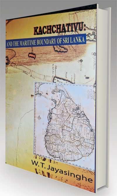 the demarcation of the maritime boundary between
Sri Lanka and India. With Indian fishermen continuing to indulge in illegal fishing in Lankan waters, the book relates how laws were brought to confine fishing to areas within the boundary of each country.
In 1957, Sri Lanka had proclaimed the rights over the continental shelf in order to take conservation measures, regulate fishing in the sea within 100 miles of territorial waters and in the Wadge Bank. The expansion of Sri Lanka’s maritime regime however, took place in the 1970s with India’s claim for Kachchativu being dispelled. It led to the demarcation of the maritime boundary between Sri Lanka and India when Sri Lanka proclaimed her sovereignty over the maritime zone now recognised under international law.
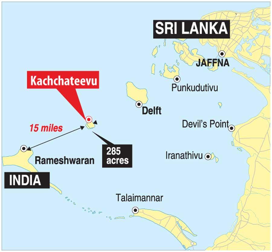
Demarcating the maritime boundary with India in the Gulf of Mannar, Palk Bay, Palk Straits and the Bay of Bengal gave Sri Lanka a clearly defined sea frontier recognised in the region and worldwide. It also opened the doors for her to utilise the marine resources within her area of sovereignty and jurisdiction. The process commenced in 1921 by the British when they defined the waters between the two countries so that each government could control and regulate the fishing in the respective areas. It was accepted that the principle of equidistance and the median line be used as the guiding factor. Sri Lanka’s British Government representative Horseburgh proposed an equal apportionment of the waters between Sri Lanka and India using the median line for division. At Kachchativu, the line was demarcated only by 3 miles west of the island in order that there is an equitable apportionment in the fisheries domain for Sri Lanka and India. The line at this distance left Kachchativu within Sri Lanka’s sovereignty and a belt of sea on its west.
The book further reveals that in the Gulf of Mannar however, the line of demarcation commenced midpoint from Adam’s bridge and proceeded Southwest parallel to the latitude 8 degrees North. The line veered more towards Indian mainland leaving a slightly larger area of sea to Sri Lanka where her main fisheries and pearl banks were located. It was at this juncture that Madras officials stated that Kachchativu island belonged to India. The British government of Sri Lanka however had been firm and insisted that Sri Lanka’s sovereignty over Kachchativu was never in question.
Madras officials had lateragreed to this and the delimitation line had been fixed 3 miles west of Kachchativu as proposed by Horseburgh and Lankan officials. The line of demarcation thus commenced from the entrance to the Palk Strait, passing mid-point between Point Pedro and Point Calimere, ran south down the Palk Bay, deviating towards the coast of India and 3 miles to the west of Kachchativu. It continued downwards to mid-point on Adam’s Bridge and southwest into the Gulf of Mannar, running parallel to Latitude 8 North.
The Madras officials on 25, October 1921, had accepted this fisheries line without prejudice to any territorial claim that India may make to Kachchativu.
The line that crossed Adam’s Bridge was fixed exactly halfway between Dhanushkody and Talaimannar, the book discloses. With there being a proposal to build a land bridge joining Sri Lanka with India, it is of interest to note that a demarcation at mid-point of the Adam’s Bridge was “agreeable to both Parties in view of the contingency that the cost of a bridge along this natural causeway is likely to be apportioned according to such a division.”
Madras representatives however, in the joint report stated that they were inclined to regard Sri Lanka’s claim to Kachchativu as sentimental rather than practical. The author feels that Kachchativu,being a barren, uninhabited islet may have prompted the observation. However, the 1921 delimiting of the sea was not implemented.
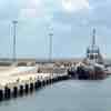
It was in the mid 1950s that Kachchativu once again became a live issue in Sri Lanka’s bilateral relations with India. By this time, the landmass which is one mile long and three quarters of a mile broad at its widest and located furthest from the shores of the mainland, was being used as a resting place of fishermen.
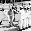
Thus when Mrs. Bandaranaike visited India in 1974, the correspondence was completed and the sovereignty of Kachchativu was signed and officially accepted by India which the author says was a remarkable demonstration of the part that personalities can play in the history of nations
The isolated islet however, comes alive in February-March when pilgrims, mostly fishermen from both Sri Lanka and India, visit the island by boat to participate in the famed Festival of the St. Anthony’s church. This sole building located on the island, is traced back to early 1900s. St. Anthony is regarded as the Patron Saint of fishermen. However, there were also reports of illicit immigrants from South India using the Kachchativu Festival to enter Sri Lanka. The use of effective measures being used to prevent illicit entrance, activated some political parties of Tamil Nadu to raise the Kachchativu issue in the Lok Sabha when the Central Government came under attack.
The book further reveals how Dudley Senanayake, during his term as Prime Minister from 1965-1970,determined to secure a favourable outcome, built a dossier on the issue. A positive outcome however, eluded him. The limits of the territorial waters had to be measured from the baselines of the territory of a state and with the sovereignty of Kachchativu in dispute, the limits of the territorial waters could not be defined with finality. Dudley Senanayake, during his first official visit to India in 1968, took the stance that Kachchativu was part of Sri Lankan territory and that it needed a withdrawal by the Indian government to the ill-defined claim allegedly based upon ownership by the Rajah of Ramnad. Senanayake recalled Indian Government’s Note of 1967 that suggested the acceptance of the 1921 line as a territorial limit which kept Kachchativu well on the Sri Lankan side. Indira Gandhi, then Prime Minister of India, appeared to have recognized Sri Lanka’s sovereignty over Kachchativu if there was some quid pro quo which she could offer the Madras Government.
With Indira Gandhi’s Party losing numbers in the Lok Sabha at this juncture, Dudley Senanayake was denied the understanding he had reached with Gandhi eluding him a positive outcome.But Mrs. Bandaranaike and Mrs. Indira Gandhi in power in the respective countries at the same time, turned out to be a happy coincidence which made way to solve issues that formed an integral element in the gamut of Indo-Ceylon bilateral relations. India however denied of having reached any consensus with Dudley Senanayake which on query by Mrs. Bandaranaike was found to be incorrect. Mr.Senanayake gave Mrs. Bandaranaike what transpired up to the time of his stewardship which prompted Mrs. Bandaranaike to write a personal letter to Mrs. Gandhi explaining of the consensus reached in 1969.
Resolving the Kachchativu issue by this time had garnered high priority in Mrs. Bandaranaike’s political agenda as was the Indo-Ceylon problem which she initiated during her first term in 1960.
Discussions at summit level therefore, were held with Mrs. Gandhi in 1973 in Sri Lanka.
New concepts were besides, emerging from the “Law of the Sea” – a conference held in New York, discussed the extent of the sea that would fall within the jurisdiction of a state or which it could exercise certain rights. And disturbing intelligence reports were also coming at this time from the North (Sri Lanka) and there was also a marked increase of cross border traffic with smuggling posing a threat to national security.
Mrs. Bandaranaike therefore, stressed the urgency of resolving the Kachchativu issue in the interest of Sri Lanka’s national security. Mrs. Gandhi indicated that the relevant officials should hold a discussion and prepare a joint memorandum which could be discussed by the two Prime Ministers. Meetings were held with Walter Jayasinghe (the author of this book) representing Sri Lanka as Foreign Secretary and C.W. Pinto acting as Legal Advisor when Sri Lanka’s sovereignty over Kachchativu was traced from 1665 in the Dutch period. And successive administrations maintained jurisdiction and control up to the present. Up to 1955, Kachchativu had been listed as a village of the Northern Province in the successive censuses. Sri Lanka also showed records of the Indian government seeking permission from the Sri Lankan government to use Kachchativu for bombardment practices for the Royal Indian Navy.
The only claim the Indians made was based on an alleged title of the Rajah of Ramnad. This was followed up with a letter from Mrs. Gandhi to Mrs. Bandaranaike which said that they have to be mindful of reactions in Tamilnadu where there are special sensitivities bearing on this issue. “Passion should not be inflamed in either country since that would defeat our objective of trying to remove an irritant in our relations. ….”
Walter Jayasinghe flew ahead of Mrs. Bandaranaike, who was going to India to participate at the
India’s Republic Day celebrations, when she further explained the highlights. The final agreement would be signed provided that the waters between South India and NW Sri Lanka be demarcated by a median line, equidistant from the Indian Coast and Sri Lanka. With Kachchativu being Sri Lanka ‘s furtherest landmass, on the principle of equidistant, Sri Lanka’s territorial sea on the western side was not to extend to mid-point between Kachchativu and Rameshwaram but be limited. The extent of the sea lost to Sri Lanka would be a concession made to India for the purpose of a settlement.
Thus when Mrs. Bandaranaike visited India in 1974, the correspondence was completed and the sovereignty of Kachchativu was signed and officially accepted by India which the author says was a remarkable demonstration of the part that personalities can play in the history of nations. The Lankan delegation included Walter Jayasinghe, Justin Siriwardene who was High Commissioner of India then, H.A.de S Gunasekere, Secretary, Planning and Economic Affairs and C.W.Pinto who was Legal Advisor to the PM.
However, the fisheries line which skirted three miles to the west of the Kachchativu was now reduced to one mile to the west resulting in Sri Lanka losing 45 square miles of fishing area. It also included that any single geological, petroleum or natural gas structure or field of any other mineral deposit if extends across the boundary line and needs to be exploited from the other side of the boundary, an Agreement should be sought.
The narrative does mention of legal steps taken challenging the Agreement but dismissed even without hearing by the Supreme Court of India.
09 Jul 2026 1 hours ago
09 Jul 2026 2 hours ago
09 Jul 2026 3 hours ago
09 Jul 2026 8 hours ago
08 Jul 2026 08 Jul 2026