18 Dec 2025 - {{hitsCtrl.values.hits}}
CNN - Hundreds of miles from China’s populous coastline, a sharp bend in a remote Himalayan river is set to become the centerpiece of one of the country’s most ambitious – and controversial – infrastructure projects to date.
There, a $168 billion hydropower system is expected to generate more electricity than any other in the world – a vast boon for China as it hurtles toward a future where electric vehicles dominate its highways and power-hungry AI models race to out-compute international rivals.
Chinese leader Xi Jinping called for the project to be “advanced forcefully, systematically, and effectively” during a rare visit earlier this year to Tibet, a region where Beijing continues to tighten its grip in the name of economic growth and stability.
Experts say the hydropower system, built in the lower reaches of Tibet’s Yarlung Tsangpo river, will be a feat of engineering unlike any ever undertaken. Leveraging a 2,000-meter altitude drop by blasting tunnels through a mountain, it will enable China to harness a major river in a region known as Asia’s water tower and at a time when governments are sharpening their focus on water security.
The project could aid global efforts to slow climate change, by helping China – now the world’s largest carbon emitter – wean off coal-powered energy. But its construction could also disrupt a rare, pristine ecosystem and the ancestral homes of indigenous residents.
Tens of millions of people also depend on the river downstream in India and Bangladesh, where experts say the potential impact on the ecosystem, including on fishing and farming, remain understudied.
Headlines in India have already dubbed the project a potential “water bomb” – and its proximity to the disputed China-India border put it at risk of becoming a flashpoint in a long-simmering territorial dispute between the two nuclear-armed powers.
Despite these stakes, the project remains shrouded in secrecy, deepening questions about a plan that shows China’s immense technical capabilities and drive for clean energy, but also its lack of transparency, even when it comes to an undertaking with potentially far-reaching consequences.
Clues about the project’s design – both referenced in official or scientific reports and from open-source information compiled by CNN – suggest a complex system that could include dams and reservoirs along the Yarlung Tsangpo river, as well as a series of underground hydropower stations connected by tunnels, harnessing energy as a diverted portion of the river makes a steep elevation decline.
“This is the most sophisticated, innovative dam system the planet has ever seen,” said Brian Eyler, director of the Energy, Water, and Sustainability Program at the Stimson Center think tank in Washington. “It’s also the riskiest and potentially the most dangerous.”
China disagrees. In a statement to CNN, its Ministry of Foreign Affairs said that the project had “undergone decades of in-depth research” and “implemented thorough measures for engineering safety and ecological protection to ensure it will not adversely affect downstream areas.”
“Since the initial preparation and official commencement of the project, the Chinese side has always maintained transparency regarding pertinent information and has kept open lines of communication with downstream countries,” the ministry said, adding that “as the project progresses” Beijing would “share necessary information with the international community” and “strengthen communication and cooperation with downstream countries.”
The project, it said, “aims to accelerate the development of clean energy, improve local livelihoods, and actively address climate change.”
But Beijing may have other priorities in mind, too. The ambitious infrastructure move comes as Xi pushes to shore up national security not just by ensuring China’s energy supply – but also tightening control along disputed borders and regions home to ethnic minorities.
“If you connect the dots of Chinese infrastructure development in the Himalayas, especially in areas where China borders India along Tibet, they are strategically placed,” said Rishi Gupta, assistant director at the Asia Society Policy Institute in New Delhi.
“The project aligns with China’s broader goal of leveraging its natural resources to consolidate control over critical regions like Tibet and its borders.”
Power play in the Himalayas
Known as the world’s highest major river, the Yarlung Tsangpo winds its way from a glacier in the Himalayas across the plateau that cradled Tibetan Buddhism, and toward the country’s southernmost edge.
One stretch of the river, tucked alongside Tibet’s de facto border with an Indian state whose land China claims, has long drawn attention for its power-generating potential.
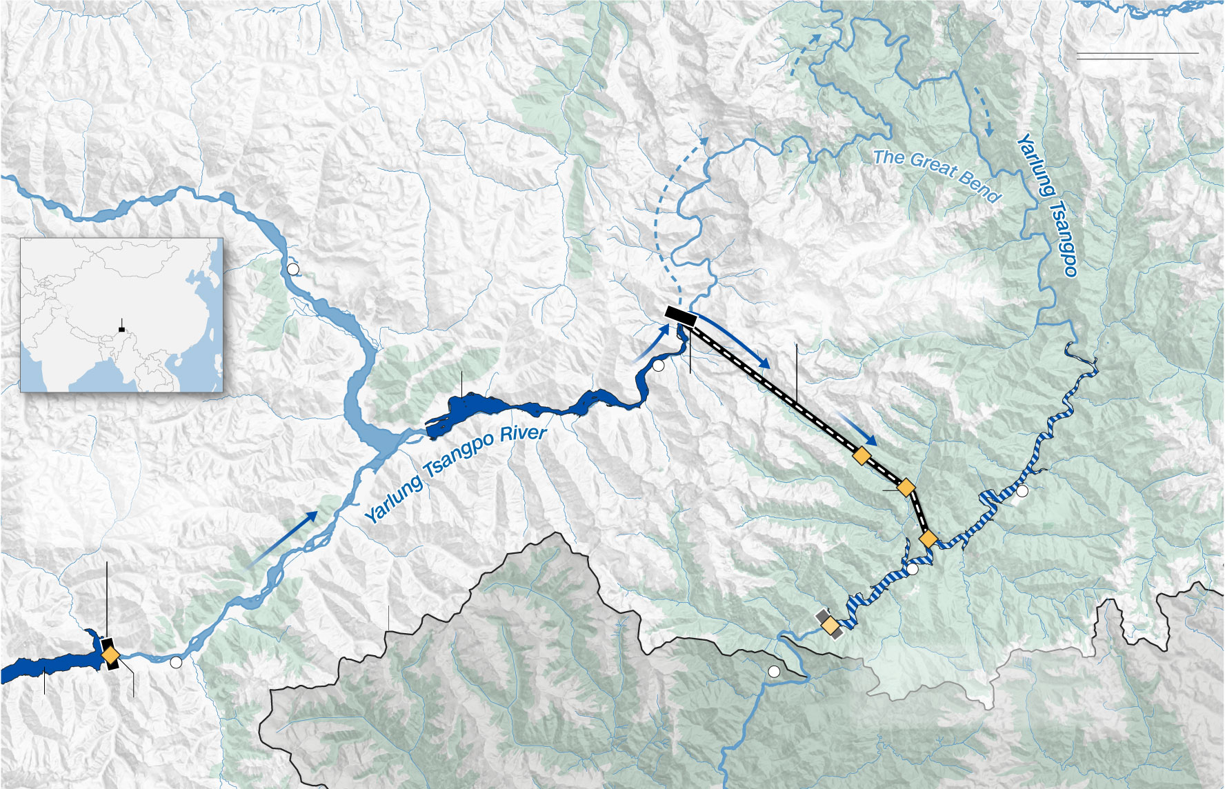
There, the waterway makes a dramatic horseshoe turn as it wraps around a mass of mountains at what’s known as the Great Bend – a trajectory that sees the river lose some 2,000 meters in altitude within roughly 50 kilometers.
That descent has been estimated to have the potential to generate some 300 billion kilowatt-hours of electricity annually – roughly triple the output of China’s Three Gorges Dam, currently the world’s most powerful.

The hydropower development on the lower Yarlung Tsangpo “isn’t merely a hydropower initiative,” it is also a national security project, encompassing water resource security, territorial security, and more, Yan Zhiyong, then chairman of the Power Construction Corporation of China (PowerChina), said in a 2020 speech, according to Chinese state media publication.
Such a project along the river’s lower reaches has been talked about for decades but never attempted – long seen as a notoriously challenging undertaking in a remote and treacherous area, difficult even for a country that leads the world in building mega-dams.
Now, satellite images, publicly available corporate documents, and social media posts from the area reviewed by CNN show work is underway building and widening roads, constructing bridges, erecting storage facilities for explosives, expanding cell service and relocating villagers – all apparent efforts to make way for construction, which officially began in July.
Official documents often refer to the project using the Roman initials “YX” to denote an abbreviation for the lower reaches of the Yarlung Tsangpo, but they provide limited information about its design. State media has said the project primarily employs a method of “straightening and diverting the river” through tunnels and includes five cascade hydropower stations.
CNN’s examination of open-source information, including academic research papers, official tenders, patents for power station designs filed by a subsidiary of PowerChina, a local town planning document, as well as satellite imagery and social media posts from the area has shed more light on how this expansive project may be taking shape.
A simulation based off this information and produced in conjunction with experts at the Stimson Center’s Energy, Water, and Sustainability Program, who provided technical and geographic analysis, suggest the design could be a sprawling system of hydropower stations, tunnels and reservoirs, which together could span some 150 kilometers as the crow flies from the first to the final power station.
That system would begin with a reservoir created by a dam at Mainling city, where Chinese Premier Li Qiang attended a groundbreaking ceremony for the project in July. The reservoir there – which could stretch dozens of miles according to the simulation – would enable operators to regulate the water flow throughout the hydropower system.
A second, lower dam, located further downstream and past a protected national wetland, would likely be used to divert a portion of the river away from the Great Bend and into a system of tunnels blasted through mountains and beneath an adjacent valley, according to the simulation of the potential design.
Here, the diverted water would likely pass through a series of cascade power stations, each hundreds of meters lower in elevation than the last – generating immense power along the way before rejoining the main river once again.
01 Jul 2026 34 minute ago
01 Jul 2026 1 hours ago
01 Jul 2026 1 hours ago
01 Jul 2026 1 hours ago
01 Jul 2026 1 hours ago