Reply To:
Name - Reply Comment


Last Updated : 2024-04-24 08:02:00
26 December 2017 01:10 am - 0 - {{hitsCtrl.values.hits}}

 When the Boxing Day Tsunami struck Sri Lanka in 2004, the casualties recorded were second only to Indonesia. These casualties were caused largely due to a lack of awareness and experience regarding tsunami warnings. Many were trapped unaware of the devastating effect as there was no public warning. Spawned by a 9.0 magnitude earthquake off the coast of Sumatra, the tsunami was one of the worst disasters in the history of our island nation.
Although the tsunami and its trail of devastation are now a faded memory, speculation was rife of a looming tsunami during the past few months. Making matters worse, a tsunami warning alert was issued on the morning of August 13, and later withdrawn by the National Tsunami Early Warning Centre of the Department of Meteorology following the 6.4-magnitude earthquake which struck Sumatra. As fear of a repetition gripped Sri Lankans over the past few weeks, today we mark the thirteenth anniversary of the Indian Ocean Tsunami.
The Daily Mirror spoke to the Deputy Director of the National Meteorological Centre in Colombo M.M.P. Mendis on how a potential tsunami threat would be detected. “We are responsible only for tsunami warnings. Once we receive the information, we analyze the data and decide if the generation of a tsunami is possible. Normally, a tsunami threat to Sri Lanka would occur when something happens in two regions close to Sri Lanka. The first is the Sumatra zone and the Makran zone in Pakistan. These two are the most vulnerable zones which would impact Sri Lanka.”
 According to Mendis, these regions are being constantly monitored by the California Integrated System Network; a network which monitors earthquakes worldwide, indicating their locations and other data of earthquakes.
Seismology or the scientific study of the movement of waves through the earth is typically associated with the study of earthquakes. Seismic networks have been established globally with the primary purpose of locating earthquakes and determining their magnitude.
“When an earthquake takes place, to verify its precise location, we need at least three locations of the Seismic Network, he said”. “The earthquake can be therefore precisely located under ten minutes. Prior to the 2004 Tsunami, there was no Tsunami Warning System in the Indian Ocean. However at present we have a well-oiled system in place. The Indian Ocean Tsunami Warning system (IOTWS) is one of them. We also receive information from the Australia Tsunami Warning System and the Indonesian Tsunami Warning System,” he said.
These systems possess a separate network to gather and share meteorological data called the Global Telecommunication Network (GTS), through which the centre receives a host of data such as the magnitude, depth, location and also whether there is a possibility of a tsunami generation.
Its state-of-the-art Indian Tsunami Early Warning Centre (ITEWC) identified as one of the best tsunami service providers in the world is tasked with providing tsunami services to 23 Indian Ocean rim countries, which includes Sri Lanka
The NMC at the Department of Meteorology in Baudhdhaloka Mawatha is however not the only station which receives such information. “We receive these messages through several dissemination models, so that if one channel fails, the message would reach us through another. Information is received through GTS, fax, telephones and emails to our centre here in Colombo, as well as our office in Katunayake. If there was any failure at the Colombo centre, the Katunayaka office will still have received the information,” Mendis explained.
The issuing of bulletins or warnings, when there is an impending disaster, takes no longer than 20 minutes, according to Mendis. “Once an earthquake is detected, it takes from 10 to 20 minutes to verify its location. An information bulletin is then prepared within 15 to 20 minutes and then we issue a subsequent warning from this centre,”he explained.
Issuing bulletins
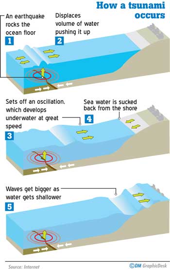
A seismometer detects the vibrations caused by an earthquake. It plots these vibrations on a seismograph. The strength, or magnitude, of an earthquake is measured using the Richter scale. The Richter scale is numbered 0-10.
The NMC has a standard operating procedure (SOP), according to which these warnings are issued. “If the magnitude is less than 6.5 - the threat of a tsunami is less, therefore we issue an information bulletin for the general public. If the magnitude is over 7, there is a chance of a tsunami, which depends on the depth. If the depth of the earthquake is more than 100 km, the possibility of a Tsunami is less,” Mendis detailed.
These warnings are first issued to the Disaster Management Centres, and then the relevant authorities, including the media, the tri-forces, Police as well the offices of the president and the Prime Minister.
Speaking of tsunami travel time, Mendis said this too depends on the location of the earthquake. “Generally, if there is an earthquake in the Sumatra area, a Tsunami will take between one to two hours to reach Sri Lanka. This time is sufficient for us to prepare for disaster management activities other than for a country like Indonesia. There is approximately a distance of 2000 km from the Sumatran coast to Sri Lanka. The maximum time taken to issue a bulletin from this centre is 30 minutes,” he said.
Can’t be predicted
Asked how the centre dealt with recent speculations and rumours of a tsunami, the NMC Director said the rumours had caused great difficulty for the centre to cope with inquiries.
“There is no mechanism to forecast a tsunami, just as there is no mechanism to predict earthquakes. We were flooded with inquires with the rumours of an imminent tsunami. It is imperative that the public understand that not every earthquake causes a tsunami, even if the magnitude is greater than 7. There are minor earthquakes which take place all over the world each day, but cause little to no harm” he underscored.
There is no mechanism to forecast a tsunami, just as there is no mechanism to predict earthquakes. We were flooded with inquires with the rumours of an imminent tsunami. It is imperative that the public understand that not every earthquake causes a tsunami, even if the magnitude is greater than 7
The Deputy Director of NMC is confident that when required, the centre will be able to promptly handle a detrimental situation, acting to inform and warn the public immediately. “There is an alarm system at our centre which triggers when there is an earthquake of a serious nature. If the magnitude of an earthquake is high, we usually don’t wait for the information. With our experience, we’re capable of promptly issuing an information bulletin to warn the public,” he said.
 Keeping waves at bay
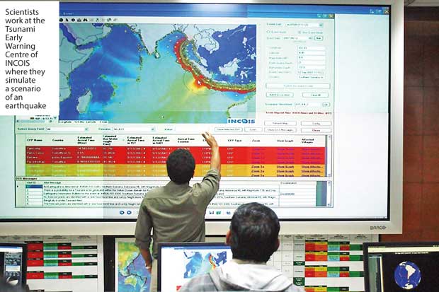
The NMC provides round the clock services supporting disaster management activities. However it isn’t mandated to collect data of earthquakes or ocean observations. One institute which provides ocean information specialising on tsunami warnings is situated in Hyderabad, India. The Earth System Science Organization and the Indian National Centre for Ocean Information Services (ESSO-INCOIS) is an autonomous body established in 1999 under the Ministry of Earth Sciences of India.
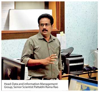
Its state-of-the-art Indian Tsunami Early Warning Centre (ITEWC) identified as one of the best tsunami service providers in the world is tasked with providing tsunami services to 23 Indian Ocean rim countries, which includes Sri Lanka. During a recent familiarization visit of a group of Sri Lankan journalists to INCOIS Hyderabad, the Head-Data and information Management Group Pattabhi Rama Rao, detailed the responsibilities of ITEWC.
“For the Indian Ocean region, INCOIS is equipped with data generated from 17 broadband seismic stations which provide data in real time. If an earthquake strikes, the centre at INCOIS receives data from around the globe. But the tsunami early warning centre gets into action when there is an earthquake
Generally, if there is an earthquake in the Sumatra area, a Tsunami will take between one to two hours to reach Sri Lanka. This time is sufficient for us to prepare for disaster management activities other than for a country like Indonesia. There is approximately a distance of 2000 km from the Sumatran coast to Sri Lanka. The maximum time taken to issue a bulletin from this centre is 30 minutes
in the Indian Ocean,” Rao explained.
“Only if an earthquake measures more than 6.5 on the Richter scale do we start issuing the Tsunami advisories. Because statistically, an earthquake of less than 6.5 can’t generate a tsunami. Although an earthquake with a magnitude over 6.5 could generate a tsunami, but it is not true in all the cases. In the Indian Ocean Region, we continuously monitor earthquakes and if there is any indication of an occurrence in the Indian Ocean and then we start acting on it,” Rao said.
“We have one Tsunamigenic zone in the Sumatra Subduction Zone, in the bay of Bengal. We have another one in the Makran Subduction Zone. If any earthquake strikes these regions, we get seismic data and then start issuing the first bulletin which is based on the earthquake magnitude,”he said.
 Issuing warnings
“Prior to issuing a second bulletin scientists at ITEWC refer to predetermined models of possible scenarios during a Tsunami generation. ITEWC employs mathematical models of tsunami wave propagation which determines the possibility of a tsunami as well as the tsunami wave heights that could be anticipated. “We have about 50,000 scenarios which are based on the data we already possess, from different earthquakes. If there is any earthquake that will generate a tsunami, it is programmed to fit the corresponding scenario. Following this match, it gives the information such as the wave height and the coastal forecast points,” Rao elaborated adding that the first observation bulletin issued within eight to ten minutes.
“For the second bulletin, which is issued within 15 to 20 minutes we analyse the likely scenarios and issue necessary advisories if the earthquake is going to generate a tsunami. It will be followed by the arrival time of the tsunami, as well as the height of the waves. For the third bulletin, we check our data against the water levels. For that we have established a chain of observation points such as the Tsunami observation buoys,”he explained.
He further added how the centre receives data regarding wave information. Rao said if there’s any earthquake which will generate a tsunami, these observation buoys will activate the tsunami mode. It transmits information to INCOIS in a high frequency mode, with detailed information on wave height. “It basically measures the pressure difference in terms of the water level. This data is transmitted to the tsunami warning centre through satellites. This is how it confirms if an earthquake will generate a tsunami,” Rao explained.
Scientists at ITEWC don’t rely on one source of information and continuously observe sea level variations in real time, which is used to validate and verify the data they receive.
“If something happens in the Sumatra region for instance, we receive information from international stations which will also confirm that a tsunami is generated. This kind of information is included in the third bulletin; any real time observations that confirm the generation of a tsunami,” he said.
“On April 11, 2012 there was an 8.1 magnitude earthquake in Sumatra. It was likely that a tsunami would be generated. We issued an advisory in order for disaster management officials to take necessary precautions,” Rao said adding that not all Early Warning Centres operate in the manner ITEWC does.
“For instance, the Pacific Tsunami Early Warning Centre doesn’t provide the quantitative information in such detail, which we believe leads to unnecessary panic among the public. At INCOIS we reconfirm the observations when each and every warning is issued,” he said highlighting the accuracy of their work.
Disaster Management
In addition to providing ocean information services, ITEWC also employs three dimensional geographical mapping system or 3D GIS to assist disaster management activities. “Thanks to 3D GIS. we can also provide disaster management officials information on which areas will be affected and how many buildings will be inundated,” he said.
“We are also capable of providing socio-economic data. Suppose a tsunami is generated during the night time, we ease the work of the disaster management officials as we possess socio-economic data such as mobile numbers for instance, through which warnings can be disseminated. We can observe how many people will occupy the vulnerable area at a given time. We have already assisted officials when during disaster situations in highly vulnerable areas of the Indian coast and are planning to extend this service to other areas,” Rao detailed.
Thanks to 3D GIS. we can also provide disaster management officials information on which areas will be affected and how many buildings will be inundated

To keep the disaster management officials updated, ITEWC updates capacity building programmes at regular intervals and also ensure that the entire system is fail-safe. “We have regular communication systems and also conduct mock drills in the national levels as well as the Indian Ocean level. We participate in the inter-government ocean commission’s tsunami warning system and Indian ocean wave exercises, every two years. In 2016 we have conducted this and a similar exercise will be conducted in 2018 as well,” the scientist revealed.
Adding a note of caution, Rao said it is imperative that disaster management initiatives are paired with tsunami warning activities, which include authorities as well as the general public. “As scientists we can issue advisories and warnings, but the disaster management officials have to get into action and then they have to provide information to those who are likely to be affected,” Rao said.
INCOIS which is in regular contact with authorities of Sri Lanka, including the Met Department has also developed an Ocean forecast system for Seychelles and Sri Lanka, in collaboration with Regional Integrated Multi-Hazard Early Warning System (RIMES). In addition to alerts on high wave, swells, tsunami, and oil spill trajectories. These forecasts, made available three days in advance for users, are updated daily on operational basis. Location specific forecasts for important local places such as fishing harbours are available for 22 locations in Sri Lanka.
Pix by Nisal Baduge & Kalani Kumarasinghe

Add comment
Comments will be edited (grammar, spelling and slang) and authorized at the discretion of Daily Mirror online. The website also has the right not to publish selected comments.
Reply To:
Name - Reply Comment

US authorities are currently reviewing the manifest of every cargo aboard MV

On March 26, a couple arriving from Thailand was arrested with 88 live animal

According to villagers from Naula-Moragolla out of 105 families 80 can afford

Is the situation in Sri Lanka so grim that locals harbour hope that they coul